
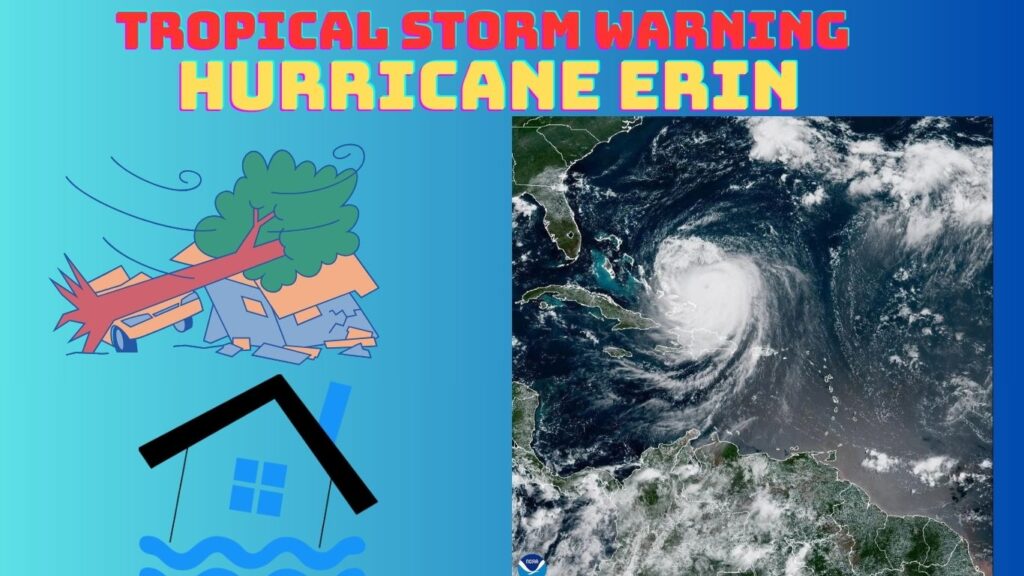
The U.S. East Coast is under a widespread tropical storm warning as Hurricane Erin, the first and strongest hurricane of the 2025 Atlantic season, swirls offshore. For many, a storm thousands of miles out to sea might seem like a distant problem, but the sheer size and immense power of Erin are proving otherwise. Its outer bands are already lashing the coast, triggering life-threatening surf, dangerous rip currents, and significant coastal flooding from the Outer Banks of North Carolina all the way to New England. State governors and emergency officials are responding with urgency, issuing public warnings, declaring states of emergency, and preparing their populations for the very real dangers approaching. This comprehensive article breaks down Erin’s evolving path, its current impacts, the full spectrum of expected hazards, and essential safety guidance to help you stay informed and safe as the storm continues its northward trek.
What Is a “Tropical Storm Warning”? A Critical Distinction
When a storm is approaching, the National Hurricane Center (NHC) issues different alerts to communicate the level of threat. Among these, the tropical storm warning is one of the most crucial. It’s not a mere advisory; it’s a declaration that tropical storm conditions—which include sustained winds of 39 to 73 mph—are expected to arrive in a specified area within 36 hours. This is a critical signal for communities to finalize their preparations and take protective action.
This is a key difference from a tropical storm watch, which means conditions are merely possible within 48 hours. The shift from a watch to a warning is a significant event. It’s a signal that the threat is no longer a possibility, but a certainty. Even more severe is a storm surge warning, which indicates the danger of life-threatening coastal flooding from rising water moving inland. This warning is often issued even when a storm’s center is far offshore, a perfect example of what is happening now with Hurricane Erin. It proves that the threat isn’t just about wind—it’s about the overwhelming power of the ocean itself.
Ultimately, these warnings matter because a storm doesn’t need to make a direct landfall to be devastating. Even a storm that stays hundreds of miles offshore, like Erin, can have a massive wind field and generate dangerous swells that travel far from the storm’s eye, causing widespread impacts.
Hurricane Erin at a Glance: A Formidable and Massive Storm
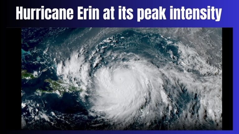
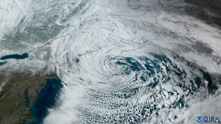
Hurricane Erin’s story is one of unprecedented and rapid intensification. The storm first formed from a tropical wave off West Africa on August 11 and quickly gained strength. By August 16, it had undergone explosive intensification, a dangerous phenomenon where a storm’s wind speeds dramatically increase in a short amount of time. In just 24 hours, Erin rocketed from a weak hurricane to a ferocious Category 5 storm, with sustained winds surging to 160 mph. It became the earliest Category 5 hurricane ever recorded in the open Atlantic.
As of Wednesday, August 20, Erin has weakened to a Category 2 hurricane, with sustained winds near 100 mph. However, its immense size remains a major concern. The storm’s hurricane-force winds extend outward up to 90 miles from its center, while tropical-storm-force winds extend an incredible 265 miles from the core. This massive wind field is why coastal communities across a dozen states are feeling the effects, even with the eye of the storm remaining hundreds of miles offshore. This deceptively large and powerful system is a serious threat that necessitates vigilance and preparedness.
Who Is Affected and Where? Impacts from the Outer Banks to New
The reach of Hurricane Erin is extensive, with impacts being felt all along the U.S. East Coast. While the storm’s path is expected to curve between the U.S. and Bermuda, the dangers on shore are very real.
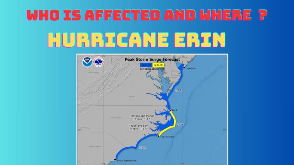
- North Carolina: The state is facing the most significant threat. A storm surge warning is in effect from Cape Lookout to Duck, with a tropical storm warning for Beaufort Inlet to Duck and the Pamlico and Albemarle Sounds. North Carolina Governor Josh Stein has already declared a state of emergency, and mandatory evacuations were ordered for low-lying, vulnerable areas, including Hatteras and Ocracoke Islands. These evacuations are critical, as the thin barrier islands are particularly susceptible to overwash and flooding.
- Mid-Atlantic & Northeast: The impacts of Erin extend far beyond North Carolina. All along the Mid-Atlantic and up into the Northeast, beaches have been closed and authorities have urged residents and visitors to stay out of the water. New York City and Long Island beaches have been closed to swimming due to dangerous rip currents and high surf. New York Governor Kathy Hochul urged residents to stay alert, noting that waves could reach 11–15 feet in coastal areas. New Jersey and Delaware are also facing high surf, dangerous rip currents, and minor coastal flooding.
- Hourly Impacts: From Florida to Maine, coastal communities are enduring life-threatening surf and rip currents. Beach rescues have been a common occurrence, with some towns reporting dozens of rescues in a single day. The hazards are not just isolated to one area but are a widespread, regional problem that will continue for days.
Potential Hazards at a Glance
The dangers posed by Hurricane Erin are multifaceted, each with the potential to be life-threatening. Understanding these threats is the first step toward staying safe.
- Storm Surge and Inundation: This is often a hurricane’s most dangerous component. The combination of wind-driven water and tide is pushing a massive amount of seawater inland. Forecasters expect coastal inundation of 2–4 feet in North Carolina, with 1–3 feet elsewhere from South Carolina to New Jersey. This water can swiftly turn a sunny day into a life-threatening situation, making roads impassable and threatening homes and businesses.
- Rip Currents and Surf: Despite the storm’s distance, its power is being transferred to the coastline through towering waves and treacherous rip currents. The NHC has warned that the surf could reach heights of 20 feet in some areas. These waves are creating incredibly dangerous rip currents that can drag even the strongest swimmers away from shore. Over 80% of annual beach rescues in the U.S. involve rip currents, and they are the leading cause of death among beach swimmers. Heeding warnings and avoiding the water is absolutely non-negotiable.
- Coastal Flooding and Erosion: The combination of storm surge and large waves is causing significant coastal flooding and severe beach and dune erosion. The main road through the Outer Banks, Highway 12, is particularly vulnerable to overwash, which can cut off entire communities. Low-lying roads and properties are at risk of being inundated, and the cumulative effect of the high surf will continue to eat away at the coastline.
What Experts Are Saying: A Warning for a Warming World
Experts from top meteorological and government agencies are sounding the alarm on Hurricane Erin’s impact and its broader implications. NOAA Director Michael Brennan has warned that the storm’s widespread impacts could last for days across the entire East Coast. The NHC’s official forecast indicates that Erin is expected to skirt between the U.S. and Bermuda, but its potential to regain strength before it eventually weakens is a serious concern.
More broadly, meteorologists and climate researchers are pointing to Erin as a stark reminder of trends fueled by warming ocean temperatures and climate change. The storm’s explosive intensification from a tropical storm to a Category 5 hurricane in just over 24 hours is a phenomenon that is becoming more common as the world’s oceans absorb heat. The rapid intensification is a dangerous trend that makes it harder for communities to prepare for and respond to storms, giving them less time to make life-saving decisions.
How to Stay Safe During a Tropical Storm Warning
A tropical storm warning is your call to action. While the official guidance will always be the most important, here are the key steps to take to ensure your safety and the safety of your loved ones.
- Avoid the Beach and Ocean: This is the most critical instruction. Rip currents are often invisible and can drag even the strongest swimmers out to sea. Do not enter the water, and teach your family members what to do if they get caught in a rip current: don’t fight it, swim parallel to the shore until you are free, and then swim to safety.
- Evacuate If Ordered: If you live in a low-lying or flood-prone area, or if local officials issue an evacuation order, do not hesitate. This is not a drill. Officials issue these orders to save lives. Have your evacuation plan ready and be prepared to leave quickly.
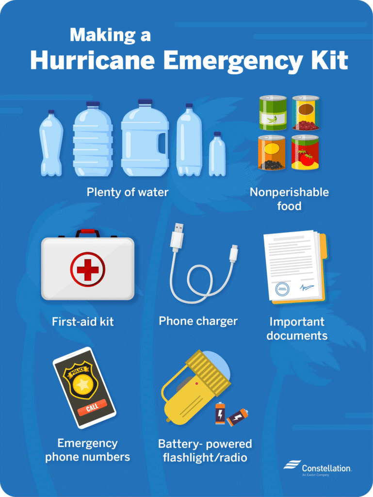
- Stay Informed: Monitor all official advisories from the National Hurricane Center (NHC), the National Weather Service, and your local emergency management agencies. Have multiple ways to receive alerts, such as a battery-operated radio and a charged cell phone.
- Prepare Now: Even if you are not in an evacuation zone, it’s essential to be prepared. Secure any loose outdoor items, such as patio furniture and garbage cans, which can become dangerous projectiles in high winds. Have an emergency kit ready with enough food, water, and essential supplies to last for at least a few days.
- Respect All Closures and Warnings: Authorities close beaches and roads for a reason. Do not attempt to bypass barricades or go to closed-off areas to take photos or see the waves. This puts not only your life at risk but also the lives of the first responders who would have to rescue you.
Conclusion
While Hurricane Erin may stay offshore, its vast size and power mean eastern coastal communities face serious and life-threatening threats. The tropical storm warning is not a mere advisory—it’s a critical signal of imminent danger. As the storm continues its northward push, it’s a stark reminder of how quickly nature can shift and how important preparedness is. By staying informed, heeding official guidance, and prioritizing safety above all else, you can navigate the storm and help your community stay safe
You Can Read More Such Articles :
Hurricane Gil 2025 , Fantastic Four Box Office , Hurricane Gil , Labubu Big Into Energy Secret , Dale Gribble , King Of The Hill Dale , Lake Piru California , Global Citizen Fest Tickets , NBA Summer League Las Vegas Tickets , Quotes for Snowfall 2025 , Farmers Almanac Winter Forecast for 2025–2026 , Hurricane Erin 2025 Tracker , Milwaukee Flooding , Times Square Shooting , Fortnite New Season Tropical Storm Hurricane Erin , 2025 Lego Batman Batmobile,Tropical Storm Warning: Hurricane , Google Pixel 10 Pro , Millie Bobby Brown Baby , North West Fashion


2 thoughts on “Tropical Storm Warning: Hurricane Erin’s Threat to the U.S. East Coast—Impacts, Forecast & Safety Guidance”