
Hurricane Gil, a Category 1 hurricane and the seventh named storm of the 2025 Eastern Pacific season, is currently holding its strength but is on a clear and rapid path toward dissipation. According to the latest advisory from the National Hurricane Center (NHC), the storm is moving swiftly over the open ocean, far from any landmass, and is not expected to pose any threat to the North American coastline. This comprehensive tracker provides a detailed look at the storm’s current status, its forecast path, and what its imminent demise means for the remainder of the hurricane season.
The Latest Data from the National Hurricane Center
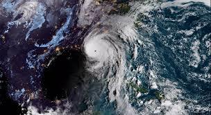
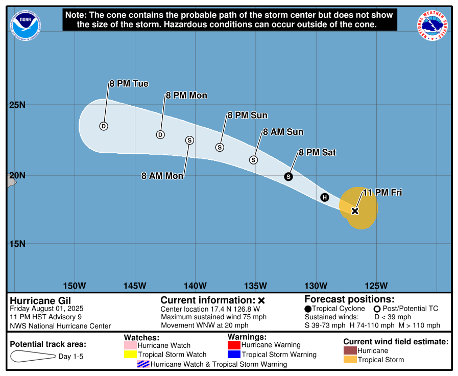
As of the NHC’s Saturday evening advisory, Hurricane Gil’s center was pinpointed at approximately 17.4°N Latitude and 126.8°W Longitude. This places the storm roughly 1,160 miles (1,865 kilometers) west-southwest of the southern tip of the Baja California Peninsula.
The hurricane is maintaining maximum sustained winds of 75 mph (120 kph), putting it at the lower end of the Category 1 classification on the Saffir-Simpson Hurricane Wind Scale. While its winds are still powerful, the system is showing clear signs that its peak intensity has passed. Hurricane-force winds extend outward up to 30 miles (50 km) from the storm’s center, while tropical-storm-force winds reach up to 125 miles (200 km). Gil is moving at a relatively fast clip, with a speed of 20 mph (31 kph) in a west-northwest direction.
The Forecast: A Clear Path to Weakening
The forecast for Gil is straightforward and provides a reassuring outlook for those on land. The storm is being steered by a strong mid-level ridge to its north, which will keep it on a west-northwestward trajectory over the next 24 to 48 hours. This path is taking it directly into an environment that is increasingly hostile to tropical cyclone development.
NHC meteorologists point to three key factors that are converging to rapidly dismantle Hurricane Gil:
- Cooler Waters: The storm is moving out of the very warm waters of the far eastern Pacific that fueled its initial formation. Sea surface temperatures are dropping significantly along its path, effectively cutting off its primary energy source. A tropical cyclone requires sea surface temperatures of at least 80°F (26.5°C) to maintain strength, and Gil is quickly moving out of that zone.
- Dry Air Intrusion: A significant mass of dry, stable air from the north is wrapping into Gil’s circulation. This dry air disrupts the storm’s moist, vertically stacked core and starves the thunderstorms needed to maintain its organized structure.
- Increased Vertical Wind Shear: The storm is entering an area of increased vertical wind shear. This is a change in wind speed and direction between the surface and the upper levels of the atmosphere. High wind shear can tear a hurricane apart by tilting its central vortex and preventing the storm’s thunderstorms from building upward.
Based on these powerful environmental forces, the NHC predicts that Gil will transition into a post-tropical cyclone as early as Sunday. By the middle of next week, the system is expected to fully dissipate into a remnant low-pressure area over the central Pacific.
What is a Post-Tropical Cyclone?
To better understand Gil’s fate, it’s important to clarify the term “post-tropical cyclone.” A storm transitions into this category when it no longer possesses the necessary characteristics of a tropical cyclone, such as a well-defined core of warm air and an organized central circulation. While a storm can lose these qualities, it can still produce high winds and heavy rainfall. In Gil’s case, however, its post-tropical phase will be brief before it completely breaks down. This classification is a critical part of the NHC’s advisory system, as it informs the public that the storm has changed its fundamental nature, even if some of its effects may linger for a short time.
Gil’s Place in the 2025 Eastern Pacific Season
While Gil itself may not be a memorable storm for coastal residents, it is part of an Eastern Pacific hurricane season that has already been quite active. This year has seen several significant storms, including Hurricane Erick, which made a historic landfall in Oaxaca, Mexico, bringing destructive winds and flooding. Its impact stands in stark contrast to that of Gil, which will pass without fanfare over the open ocean.
The season has also produced a total of seven named storms so far, with Gil being the fourth to reach hurricane strength. The number of storms is ahead of the historical average for this point in the season, aligning with pre-season forecasts that predicted an above-average to near-average level of activity. Continued monitoring of systems like Gil provides invaluable data for meteorologists, helping them to refine long-term seasonal forecasts and better prepare for future, potentially more dangerous, storms.
Official Advisories and Public Safety
For residents, travelers, and maritime interests in the Eastern Pacific, the National Hurricane Center’s advisories are the definitive source of information. The NHC issues public advisories at least every six hours at 5 AM, 11 AM, 5 PM, and 11 PM EDT. These advisories provide real-time updates on a storm’s position, strength, and forecast track.
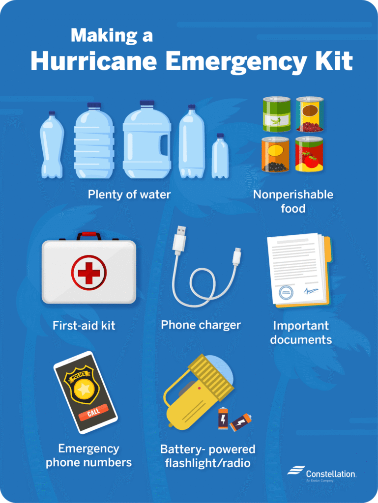
While Hurricane Gil poses no immediate threat, its passage serves as a valuable seasonal reminder. It is crucial for anyone in coastal areas to have a well-established hurricane preparedness plan. This includes having an emergency kit, knowing evacuation routes, and staying informed through reliable, official weather channels.
Conclusion: No Landfall, Just a Meteorological Milestone
Hurricane Gil’s life as a powerful Category 1 storm is coming to an end. It is a classic example of a storm following a well-understood path into an unfavorable environment, a meteorological event that is both predictable and non-threatening to the public. As it weakens and dissipates, it concludes its role not as a destructive force, but as a key piece of data in an active hurricane season, helping forecasters and scientists to better understand the complex and powerful weather patterns of the Eastern Pacific.
Hurricane Erin 2025 Tracker: Latest Updates & Alerts
Milwaukee Flooding: A Complete Guide for Residents
Times Square Shooting: What Happened in NYC’s Iconic Spot

NOAA Hurricane Joyce: Tracking the Storm and What It Means for the 2025 Hurricane Season

WWE SummerSlam 2025: Two-Night Spectacle at MetLife Stadium

Fantastic Four Box Office: Marvel’s Reboot Marks a Strong Start Despite Steep Drophttps://globaleranews.com/fantastic-four-box-office-marvels-reboot-marks-a-strong-start-despite-steep-drop/
You Can Read More Such Articles :
Hurricane Gil 2025 , Fantastic Four Box Office , Hurricane Gil , Labubu Big Into Energy Secret , Dale Gribble , King Of The Hill Dale , Lake Piru California , Global Citizen Fest Tickets , NBA Summer League Las Vegas Tickets , Quotes for Snowfall 2025 , Farmers Almanac Winter Forecast for 2025–2026 , Hurricane Erin 2025 Tracker , Milwaukee Flooding , Times Square Shooting , Fortnite New Season Tropical Storm Hurricane Erin , 2025 Lego Batman Batmobile,Tropical Storm Warning: Hurricane , Google Pixel 10 Pro , Millie Bobby Brown Baby , North West FashionGears of War Reloaded , Alcaraz’s Bold New Look , Taylor Swift Engaged?,Caitlin Clark Injury Update , Pokémon Global Offensive ,


18 thoughts on “Hurricane Gil Eastern Pacific Tracker: Path, Strength, and What to Expect”